Where Is Saadani National Park? A Guide to Tanzania's Coastal Wilderness
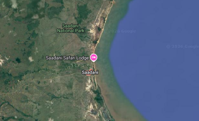
Saadani National Park sits on the central coast of Tanzania, in East Africa, directly on the shores of the Indian Ocean. It is the only national park in Tanzania that borders the sea. Roughly 130 kilometres north of Dar es Salaam and about 75 kilometres south of Tanga, it occupies a stretch of coastline between the historic towns of Bagamoyo and Pangani, facing Zanzibar across the water. If you are tracing your finger up Tanzania's coastline from Dar es Salaam, past Bagamoyo, past the Wami River, and on toward Pangani, you are tracing the edge of Saadani.
But as with anywhere worth visiting, the full answer is more interesting than the coordinates. Where Saadani sits — on the seam between land and ocean, between savanna and mangrove, between the safari circuit and the Swahili coast — is precisely what makes it one of the most unusual parks in Africa.
Exactly Where It Lies
Administratively, Saadani spans two regions of Tanzania. The southern portion falls within the Pwani Region, in Chalinze District. The northern portion lies in the Tanga Region, in Pangani District. The park covers approximately 1,100 square kilometres, stretching from the flat coastal plains inland to low, rolling hills covered in acacia and coastal forest.
Its coordinates are roughly 6 degrees south latitude and 39 degrees east longitude — just a few degrees below the equator. That position places it firmly in the tropics, which is why the heat, the humidity, and the lushness of the vegetation feel so different from the dry, highland parks of northern Tanzania.
To the east, the park opens onto the Indian Ocean. To the west, it stretches inland toward the Zaraninge Forest and the plains beyond. The Wami River — one of the park's defining features — cuts through the landscape, flowing eastward from the interior before emptying into the sea. Along its banks, hippos wallow, crocodiles bask, and elephants come down to drink, bathe, and play.
Its Neighbours and Nearby Towns
Saadani does not sit in isolation. It is part of a coastal corridor that includes several other protected areas and historic settlements, all within a few hours' drive.
To the south lies Bagamoyo, one of the most historically significant towns on the East African coast. For centuries it was the terminus of the slave and ivory caravans that came from the interior, and the point from which captives were shipped across to Zanzibar. Today it is a quiet, atmospheric town with a UNESCO-nominated old quarter, a museum, and a long stretch of beach. Many visitors combine a night in Bagamoyo with a stay in Saadani.
To the north lies Pangani, a sleepy coastal town at the mouth of the Pangani River, once a major port for the ivory and slave trades and now a base for river cruises, diving, and visits to nearby sandbanks and reefs. The park's Madete entrance gate lies close to Pangani, making it a convenient access point for travellers arriving from the north.
Just offshore, across the Zanzibar Channel, sits Zanzibar itself. On a clear day, the island is visible from parts of the park's coastline. This proximity is why Saadani pairs so naturally with a Zanzibar beach holiday — the two are separated by only a short flight or a ferry crossing plus a drive.

Inland from the coast, the landscape transitions into the plains and hills of Tanzania's interior. Beyond them lie the well-known safari circuits of the north — the Serengeti, Ngorongoro, Tarangire, and Manyara — but those are a full day's drive away. Saadani is very much its own destination, a coastal park rather than a northern-circuit add-on.
How to Get There
Saadani is accessible by both road and air, though the road journey is part of the experience.
By road from Dar es Salaam: The most common route runs north from Dar es Salaam through Bagamoyo to the Gama or Wami entrance gate, a distance of roughly 131 kilometres. The drive takes four to five hours depending on road conditions, which can become slow and rutted after heavy rain. The route passes through villages, coconut plantations, and the kind of coastal scenery that makes even a long drive feel worthwhile.
By road from Tanga: Travellers coming from the north typically route via Pangani and Mkwaja to the Madete entrance gate, a distance of about 146 kilometres. This is a beautiful drive through coastal forest and small settlements, and it pairs well with a stay in Pangani before entering the park.
By road from Chalinze: An alternative route runs from Chalinze through Miono to the Mvave entrance gate, a distance of roughly 225 kilometres. This is sometimes used by travellers arriving from central Tanzania.
By road from Arusha: For those coming from the northern safari circuit, the route via Mkata to the Madete gate covers about 79 kilometres from Mkata — though the full journey from Arusha itself is considerably longer, and most travellers choose to fly.
By air: Saadani has its own airstrip, served by charter flights from Dar es Salaam, Zanzibar, Tanga, and Arusha. A flight from Dar es Salaam takes less than half an hour — a striking contrast to the four to five hours by road — and offers spectacular views of the coastline and the Wami estuary on approach. Flying in is the most comfortable option for travellers combining Saadani with Zanzibar or the northern parks.
Photo Gallery